The Iso4App API is a service of the K-SOL S.r.l. based onto OSM data; it's purpose is to provide isodistances, isochrones, iso-populations on road network, thematic map with demographics or other data, distance matrix and marine isodistance (which coasts I reach). We provide our technology ready to use in our web application or as software as a service (javascript library or rest api). The web application allow a user to save a scenario in his iso4app account and view them later, in addition it is possible to export the scenario in geojeson, kml or kmz. In case you need help please don't hesitate to contact us at .
You can stay up to date with Iso4app on Twitter
An isochrone is defined as a line drawn on a map connecting points at which something occurs or arrives at the same time. In transportation planning isochrone maps are commonly used to depict areas of equal travel time.
With Iso4App you can draw up to 5 hours isochrones.
Support for walk, car, bike
Predefined speed levels and customizable speed value
Flags to reduce queue time and avoid tolls
The iso4app algorithm calculates the isochrones for motor vehicles using the following data: road speed limit, traffic lights, stops, roundabouts, sharp curves, type of paving.
Isodistance is a polyline of equal distance from a given point. With Iso4App you can draw up to 500 kilometres isodistances.
Support for walk, car, bike
Flags to avoid tolls
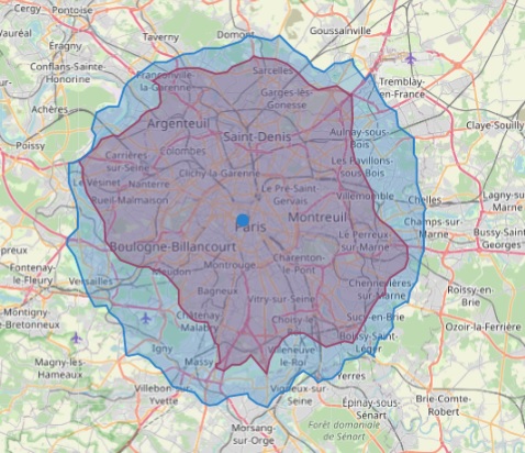
Isodistances with Fastest Routing option. You can check this option for isodistances/motor vehicle. Without this option the shortest path will be calculated, all route will be taken. Checking this option the fastest route will be taken and the polygon will be smaller, this is because usually the fastest roads are longer than the other roads. We suggest to use this option for transport planning.
Below an example of 300 km and 20 km isodistance with and without this option:
For Isochrones and Isodistances on road network it is possible to change the output polygon based on your needs:
Customizable buffering level: enlarge the original polygon up to about 80 meters
This feature can be useful to include residential areas near the edges of the polygon.
Customizable concavity level: from convex to higher concave polygon (9 concavity level)
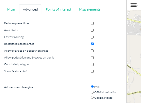
Other features: flag to allow bicycles on pedestrian areas; flag to excludes restricted access areas; flag to allow pedestrian and bicycles on trunk; constraint polygon: isolines will be bound to this constraint polygon.
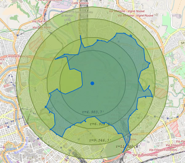
Are you using circumferences to do your analysis? Your calculations may be wrong by more than 40% up or down.
Do you see any circles that can well approximate the isochrone?
Look to the future. Stay one step ahead!
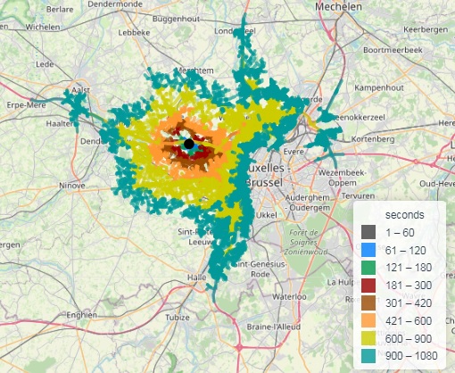
Street-Network view . You can display the street network instead the polygon.
Below an example of 6 minutes motor vehicle. Depending on your parameters you will have up to ten ranges of distances. All street segments belonging to a range will have the same color.
Street-Network view is subject to limitations: distances and geographical zones.
Street-Network and massive calculation .
You can calculate how to cover a city area using the
street network and the massive isoline calculation. This methodology can be applied to all situations where it is necessary to cover the road network with services or equipment within a given distance or time.
How to calculate the total length of roads.
When you request the street network, the system automatically calculates the total length of the roads involved. The value is stored in the marker popup.
Albania | Andorra | Australia Oceania | Austria | Beijing | Belarus | Belgium | Belize |
Bogotá | Bosnia Herzegovina | Bulgaria | Canada | Canary Islands | Costa Rica | Croatia | Cuba |
Czech Republic | Denmark | Dominican Republic | El salvador | Emirates | Estonia | Falkland Islands, | Finland |
France | French Guiana | Germany | Georgia | Great Britain | Greece | Guatemala | Guyana |
Honduras | Hong Kong | Hungary | Ireland and Northern Ireland | Italy | Jamaica | Japan | Kosovo |
Kuwait | Latvia | Liechtenstein | Lithuania | Luxembourg | Macedonia | Malaysia and Borneo island | Mexico |
Moldova | Monaco | Montenegro | Netherlands | Nicaragua | Oman | Panama | Poland |
Qatar | Russia | Saudi Arabia | Serbia | Slovakia | Slovenia | South Africa | Spain |
Sweden | Switzerland | Turkey | Ukraine | USA |
(*) isolines are limited to the zone boundary.
This zone is not connected to other neighboring zones covered by Iso4App.
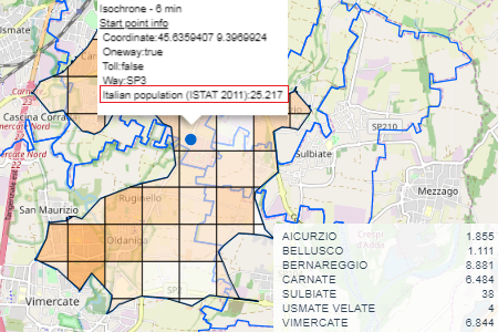
Iso4App allow you to see filled isolines on road network with thematic map. See below the screenshots:
The screenshot above show you two examples of thematic map: Italian Population and England/Wales population, as you see you can have: the total value, a value for each element on grid, a value for each administrative boundary.
Available Categories:
WORLD WIDE
From OSM: Accomodation, Amenity, Education, Food, Health, Bank/Exchange, Shop, Sport, Tourism, Transport.
AUSTRALIA
From ABS census 2019: Australian Population. Australian Average Age.
AUSTRIA
From HDX 2020: Austria Population by sex.
BELGIUM
From STATBEL 2020: Belgium Population.
DENMARK
From DST 2024: Denmark Population by sex and Average Age
FINLAND
From STATISTICS FINLAND 2022: Finland Population by sex or age.
FRANCE
From INSEE census 2020: France Population. France Average Age.
GERMANY
From STATISTISCHE ÄMTER census 2011: Germany Population. Germany Average Age.
GREECE
From GEODATA.GOV.GR estimates 2020: Greece Population
ITALY
From ISTAT census 2011: Italian Population. Italian Average Age. Foreigners+Apolides. Homes,Families,Residential Buildings
From ISTAT permanent census on 1st January 2022: Italian Population. Italian Average Age.
From MEF declaration 2017, 2018, 2019 and 2022: Italian income.
NETHERLANDS
From CBS 2022: Netherlands Population
NORWAY
From SSB 2024: Norwegian Population
PORTUGAL
From INE 2018: Portugal Population
SOUTH AFRICA
From STATS SA census 2011: Population by group, income category and education level.
SPAIN
From INE census 2018: Population.
SWEDEN
From SCB 2020: Sweden Population.
SWITZERLAND
From STATPOP census 2018: Swiss Population. Swiss Average Age.
UNITED KINGDOM
From ONS UK Population estimates 2020: England/Wales Population and England/Wales Average Age.
From ONS UK Income estimates financial year ending 2020: total annual income and net annual income.
From POLICE UK Crime 2018 and 2019. Want to know what crimes by type have been committed where you live? i.e. 5-minute walk from your home.
UNITED STATES
From U.S. Census Bureau census 2010: Population and Average Age.
More information on thematic map/catchment area and data source.
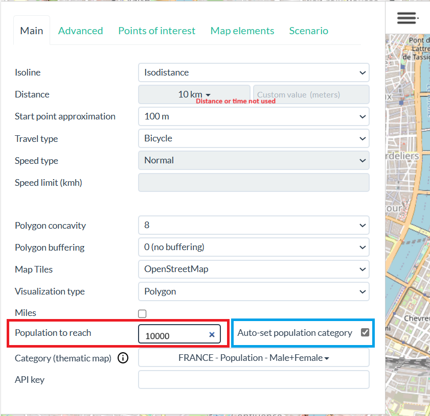
This feature allows you to calculate an isochrone or an isodistance without specifying time or distance, but specifying the number of people to reach.
After selecting the parameters of interest (isodistance or isochrone and related parameters), it is necessary to specify the number of people to reach.
To perform the calculation you must also select a thematic map of population type. However, if you want to be helped by the system simply select the Auto set population category option.
This option automatically selects the correct thematic map based on the country displayed in the center of the map, however this option always selects the total population (male + female).
If you want to customize the selection you must change the choice in the thematic map menu.
The resulting isochrone or isodistance will have the specified population with a ±5% approximation.
The population value accepted for the calculation must be between 1000 and 500000.
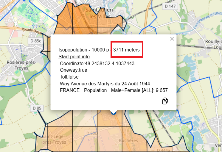
The starting point pop-up window shows the distance or time used to reach the specified population.
Our company specializes in providing GIS solutions. If you prefer we can collaborate with you in integrating our APIs into your application, in addition we can help you to implement fully GIS based applications or GIS based ad-hoc components.
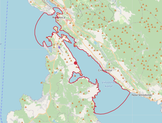
By clicking on the sea, the marine isodistances feature show the navigation reachability based on nautical miles.
This service is available in all seas of the world. Depending on the number of miles (between 1 nm and 2500 nm), and the complexity of the coasts involved, the service can respond online or on a deferred basis.
The system makes approximations based on the chosen distance, for small distances the system is very precise, for other distances an approximation of the coasts is applied which however is negligible in relation to the chosen distance.
Additional information at Nautical Distance Map
If you want to play around with the Iso4App API and see all the features in action, we have built a web app for you to try out everything.
Toolbar on the web app
Icon | Description |
---|---|
Map Zoom | |
Find location by address/coordinates | |
Massive isoline calculation. You can add your coordinates or you can load automatically the coordinates of Layer POIs shown on the map | |
Distance Matrix calculation | |
Join isolines on the map | |
Download isolines in GeoJson format (one file) | |
Download isolines in KML format (one file) | |
Download isolines in KMZ format (one .ZIP file that contains one .kmz for each isoline) | |
Aerial distance between two points | |
Save only visible or all Map Elements. After saving you can select it in the Scenario section. |
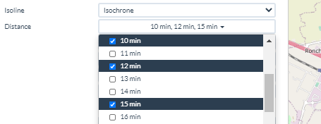
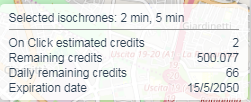
Isochrone/Isodistance selection: you can select/deselect one or more isolines which are summarized in the info window:
Isochrones selection | Info window |
---|---|
Marine Isodistance selection: you can select only one distance:
Advanced parameters: Google Places search. The default search is performed by Esri search, but you can use also the OSM Nominatim or Google Places search
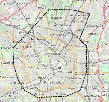
Advanced parameters: Constraint Polygon.
As you can see in the previous sceenshoot you can add a your custom polygon (kml or kmz) to the map. This polygon will be showed in dotted format and the subsequent isolines will be bound to this constraint polygon.
Constraint polygon file selection | Constraint polygon on the map | Constraint polygon with bounded isolines |
---|---|---|
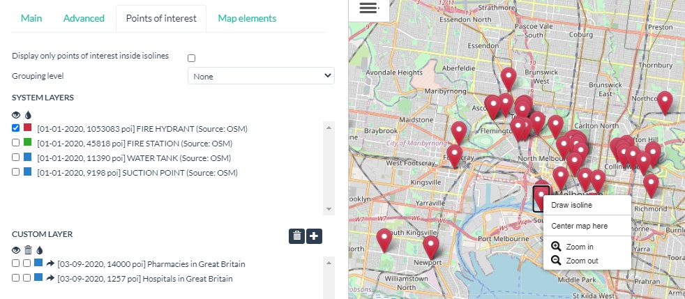
Points of interest: in this section you can view the system POIs by selecting one or more system layers or you can add your POIs adding a custom layer. Only your API-Key can view the added layers. The custom layer are not public. Grouping POIs feature is available. If on the map there are isolines you have the option to show only POIs inside it. You can choose the pin color for each selected layer or to go in the map zone where the POIs layer are present. Using the right mouse menu you can draw isolines on it. If you open the massive isoline window, with a single click you can calculate isolines for each POI in the map.
Points of interest layers |
---|
Map elements : in this section you can view the list of object present on the map. Map elements are: isochrones and isodistances polygons, isochrones and isodistances street network and thematic map. POIs are not considered map elements so you have to manage it using the section Points of interest. For each map element you can hide/show/remove it or to go in the map zone where the element is present. Restriction: you can have more thematic map, however only one at a time can be shown on the map, because each thematic map has its legend.
Maps elements |
---|
Scenario : in this section you can view the list of scenario that you saved.
A scenario is a collection of Map Elements that you have saved by giving it a name.
Selecting a scenario it will be displayed on the map and the each element will be the original ones and not recalculated.
After selection each elements will be inserted in the Map Elements section.You can Hide/Show these elements, but you cannot remove it. You can Show/Hide/Remove the whole scenario from its section.
When you save a scenario in which there are active Points of interest layers, only the POIs that are currently visible on the map will be saved and not all the POIs of the selected layer.
Each saved scenario is linked to your API-Key, only you can see it.
Scenario section |
---|
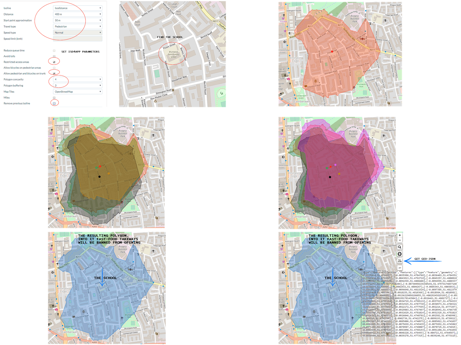
Total ban on fast-food outlets within 400m of London schools, Mayor Sadiq Khan to announce.
The question is: how to calculate correctly the 400 meters walking around a school?
Answer: use iso4app service as showed into the animated image.
1) Find the school
2) Analyze the streets around the school
3) Click on one or more points
4) Join the resulting polygons
4) Get the final GeoJson polygon
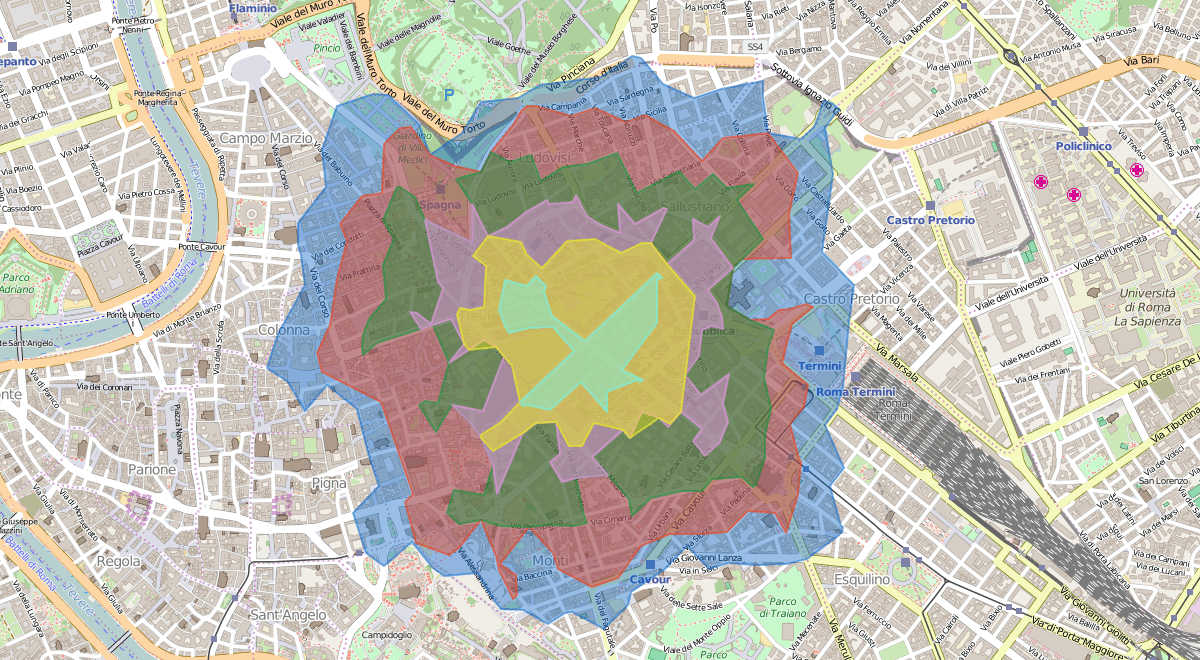
You can study the reachability in time or distance from a given starting point.
In the example the pedestrian reachability from the center of Rome at intervals of 2 minutes.
Within your isoline you can represent a statistical indicator.
Suppose you have to open a new store and that you have the demographic data of your region.
You can represent your demographics within your isoline.
In the example a thematic map within an isodistance starting from the Italian ISTAT demographic data of the last census.
Suppose you want to know the gas stations that you can reach by car in less than 3 minutes.
If you have the POI database you can use our isolines to provide this type of service to your users.
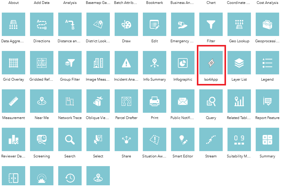
You can use Iso4App also on ArcGis Web AppBuilder. Below you can download the Iso4App widget that you can include in your ArcGis application.
Unzip the Iso4app.zip file. After unpacking you will find the Iso4App directory, copy it to the Web AppBuilder configuration directory ArcGISWebAppBuilder\client\stemapp\widgets. Then restart Web AppBuilder.
On Web AppBuilder create a new Web App, select the Widget section and add the Iso4App Widget selecting it fromthe list.
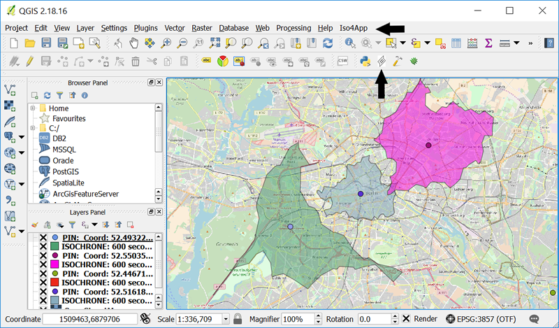
You can use Iso4App also on QGIS Desktop platform.
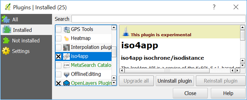
You can install the Plugin directly from QGIs Plugins->Manage and Install Plugins... Search iso4app, select and install it.
You can also download the Iso4App Python plugin zip file from https://github.com/ksolsrl/QgisIso4app.
You have to unzip and copy it under the python plugin folder.
Restart QGis and enable the plugin from Plugins->Manage and Install Plugins...
This plugin is compatible with QGis 3.X
Plug-in parameters.
Notes:
Isoline Type: you can select the type of isoline to display: Isochrone or Isodistance.
Common parameters: we suggest to keep checked the option Restricted areas. A set of many conditions defines a restricted road: roads that can be closed at certain times, reserved lanes, port areas or service areas, roads with access limits, ....
Isochrone parameters: Speed type: set Very low for intense traffic, set Low for medium traffic, set Normal for little traffic, set Fast in this case the maximum speed allowed on the road is used.
Reduce queue time:use it if you can skip the queue at a traffic light, for example if you drive a moped or an ambulance.
Speed limit: if your veichle cannot exceed a specific speed (Ex. a truck 80 kmh, a moped 50 kmh,...) you can set this parameter.
Specific pedestrian and bike parmeters: in UK we suggest to keep checked Pedestrian and bicycle on trunk.
Isodistance parmeters: Fastes Route: this option uses the fastest roads and not the shortest roads.
Output types: Polygon: you have a polygon.Street Network: you have a set of segments over the map roads.
Polygon attributes: Concavity: 0 is a convex, higher values result in a more concave polygon. Buffering: enlarges the polygon by about 10 meters for each unit
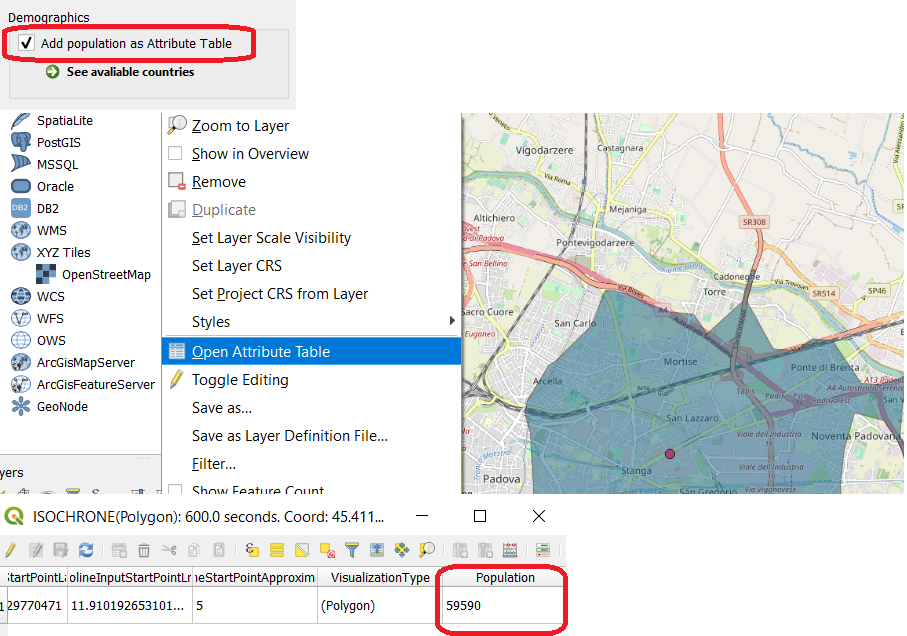
Demographics: Add population as Attribute Table: valid only for output=polygon if the isoline is in a country where the population is available the attribute population will be added in the Attribute Table
How to calculate massive isolines from multiple points contained on your own layer.
An example of layer (MyLayer) containing points.
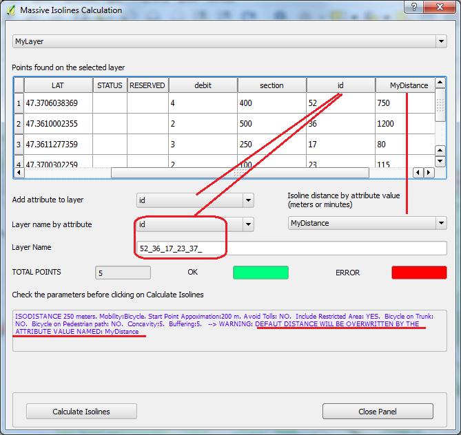
From iso4app menu select Massive Isoline Calculation.
From the opened panel select a layer (in this case MyLayer).
You have a Layer points list. For automatic layer name based on attributes value select an attribute from the combo, otherwise write your preferred layer name. In addition you can: 1) select an attribute to add, for each polygon, in the attribute tables; 2) use your attribute as a distance (it will be read as meters for isodistances or minutes for isochrones).
Before click on Calculate Isolines check well if the isoline parameters are set as you wish. Below the new isolines layer
The attribute table of the new layer.
Iso4app plugin for QGIS resources:
How to draw isochrones and isodistances.
Massive isodistances calculation from your layer.
Massive isochrones calculation with a different travel time for each point.
You can use Iso4App to calculate the distance or time matrix. In the isoline parameters panel by setting isochrone, and all related parameters, you will have a matrix of travel times in seconds, by setting isodistance, and the related parameters, you will have a matrix of the distances in meters. Based on the parameters, it will be possible to calculate the distance or time matrix for motor vehicle, bicycles or pedestrians.
Steps to use distance matrix:
Setting isoline parameters and your API-Key
Click on the Distance Matrix icon located on the right side of the web app:
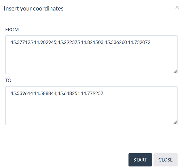
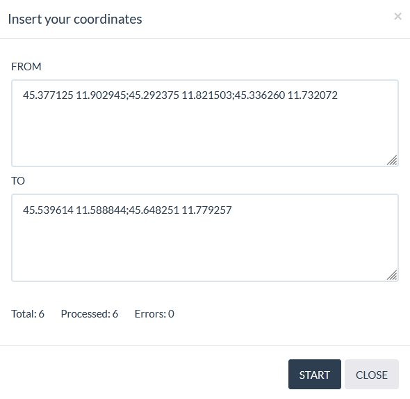
On the Distance Matrix panel enter the starting coordinates (FROM) and the arrival coordinates (TO). Sintax: latitude1 longitude1;latitude2 longitude2; and so on...
Click on START button, the working in progress calculation will be updated. If you need to stop processing click on STOP button
At the end of the processing, click on CLOSE, the Distances Matrix table will be shown, you can copy the table on clipboard using the copy icon
Checking your points on the map: the starting points are gray with a blue dot, the arrival points are gray with a red dot; moving the mouse over an element of the table, the relative starting point becomes blue with a white dot and the end point becomes red with a white dot.
Click on X icon to remove the table, the points on the map will be removed.
Restriction: maximum distance 300 kilometers, maximum time 3 hours, the points must belong to the same connected graph
The Iso4App JavaScript API is a JavaScript library designed for mobile-friendly geographics maps.
Its purpose is to provide you with the wgs84 coordinates of your preferred isoline.
You can use iso4app library to draw your isoline using your preferred maps api.
Since this API makes requests to the Iso4App Webservice you need to register to get your API key.
The API key has a limited number of credits and you can use it for development purposes only.
If you like the service you can purchase more credits. Is available also a rest api click here for more information.
In this section you will find the basic usage of the Iso4App JavaScript API. For more detailed information about the services, information on the utility classes, please have a look at the API section.
This sections represents the reference about the iso4app engine
offered by the Iso4App JavaScript and Rest API. We discuss all the mandatory and optional parameters and the constants you can use during invocation.
Freemium (no registration) | Freemium (registration required) | Premium (registration required) | Educational | |
---|---|---|---|---|
10 km isodistances | x | x | x | x |
10 minutes isochrones | x | x | x | x |
Isodistances between 100 meters and 30 km | x | x | x | |
Isochrones between 1 minute and 30 minutes | x | x | x | |
Iso-Population between 1000 people and 20000 people | x | x | x | |
Marine isodistance between 1 and 5 nautic miles | x | x | x | |
Isodistances between 30 km and 500 km | x | x | ||
Isochrones between 30 minutes and 5 hours | x | x | ||
Iso-Population between 20000 people and 500000 people | x | x | ||
Marine isodistance greater than 5 nautic miles | x | x | ||
Display of the street network instead of the polygon | x | x | x | x |
Thematic Map: Demographic/Economic categories | x | |||
Thematic Map: OpenStreetMap categories | x | x | x | x |
Google search place | x | |||
Esri search place | x | x | x | x |
Nominatim search place | x | x | x | x |
Points of interest (System Layers) | x | x | x | x |
Points of interest (Custom Layers) | x | |||
Save screen | x | x | x | x |
Massive isoline calculation | x | |||
Download isoline in Geo-Json format | x | |||
Download isoline in KML format | x | |||
Download isoline in KMZ format | x | |||
Save isoline on map as Scenario | x | |||
Distance matrix | x | |||
Join isolines on map | x | |||
Measure aerial distance | x | x | x | x |
Add constraint polygon on map | x | |||
Isoline REST Api | x | x | x | |
QGis plugin | x | x | x | |
Freemium (no registration)
Only few requests are allowed.
Freemium (registration required)
After registration we give you a personal API Key by which you can ask for isochrones until 30 minutes and isodistances until 30 km.
This API key is limited in credits and time.
Premium (registration required)
You can extend your API Key purchasing new credits. All features are enabled and you can ask for isochrones until 5 hours and isodistances until 500 km.
Credits cost:
Available license:
Purchase a quatity of credits valid for one year
- Start from 16000 credits.
- You can recharge it at any time.
- After the expiration your API-Key will be stopped, however the ramaining credits will be valid and usable after a recharge.
Purchase a quantity of credits at a low price for a quick analysis. The credits will be valid for 2 weeks
- Start from 16000 credits.
- You can recharge it at any time.
- After the expiration your API-Key will be stopped, however the ramaining credits will be valid and usable after a recharge.
Options and prices available after registration!
Payment in advance!
No auto renewal!
Educational plan
- you have to sign up using your educational email, after that, email us asking to activate the educational plan.
- Your account will be update adding 1000 credits and the license will be valid for 3 months.
- This license does not allow to download vectorial data.
IMPORTANT NOTICE: PLEASE READ CAREFULLY BEFORE USING THE DATA SERVICES
This end user service license agreement ("Services license agreement") is a legal agreement between you (the "End User" or "You") and K-SOL S.r.l. The terms of this services license agreement are intended to govern the use of our isolines services (Iso4App).
If you do not agree to all the terms of this services license agreement, we are unwilling to provide you with the services and you must not use our services and you will have no right to access or use our services. If for any reason you have already used our services and you have stored isolines data and no longer agree to all the terms of this data license agreement you must remove all the data you have stored.
In exchange for a fee, you can use Iso4App services for a period of time and for a number of requests. You can use Iso4App service free of charge only for test purpose and with the limits below:
1. Freemium without registration: you can ask for 10km isodistances and 10 minutes isochrones.
2. Freemium with registration: you can ask for every type of isolines. Your API key is limited in credits and time.
A. API (Rest or Javascript) and QGIS Plugin
You must not pre-fetch, cache or store any content, except that you may store a limited amounts of content for the purpose of improving the performance of your application
1. You are not allowed to pre-fetch
2. Data conservation has to be temporary
3. Data has to be kept in small amounts
If you need save the isolines on your system you have to purchase the extended right. During purchase process you can specify this option (default YES). If you do not have this extended right and you have already purchased credits you can require it emailing us, we will configure your API-KEY. When you have the extended right additional credits consumption will be added in the same way as downloading the isolines from the Iso4App Web Application. You can keep the isolines in your system for approximately one year.
B. Iso4App Web Application
1. You can save isolines on your PC using a paid API-Key
2. Saving isolines consumes credits
3. The saved isolines can be imported on you system
4. You can keep the isolines in your system for approximately one year
Keep in mind that the following changes: one-way,speed limit, adding/removing stops, traffic lights and roundabouts changes the shape of the isolines. We suggest updating the isolines every 4 or 6 months
C. Substitute service
1. You must not attempt to create a substitute or similar service through the use of or an access to the iso4app service.
2. You cannot publish a general service layer to show isolines on other applications. Our service must be used on a specific end-user application.
D. Account validity
1. Your account remains valid for 6 months after the expiration date, after this time we have the right to remove any remaining credits.
2. To delete all data from your account you must explicitly request it.
We may collect informations such as, but not limited to, an end user's ip address, requests, time of submissions and the results returned to the user, in connection with transaction requests to the services.
Subscriber uses the services at subscriver's sole risk. The services and content are provided on "as is" and "as available" basis. Unless otherwise explicitly stated, the services or content on the iso4app web site is not intended for use in any mission critical applications. Iso4app disclaims all implied conditions, representations, and warranties of any kind, including any implied warranty of merchantability, fitness for a particular purpose, or noninfringment. Iso4app makes no representation, warranty, or guaranty as to the quality, suitability, truth, accuracy, or completeness of any of the services or content contained on their web sites.
The services and content have been developed from sources believed to be reliable, but their accuracy and completeness are not guaranteed. the services and content may contain nonconformities, defects, inaccuracies, errors, or omissions. Iso4app makes no warranty that:
A. the services will meet subscriber's requirements;
B. the services will be uninterrupted, timely, secure or error free;
C. the results that may be obtained from the use of the services will be accurate or reliable;
D. the quality of any services, data or information obtained by subscriber through the services will meet subsrciber's expectations;
E. any errors in the services, software, data, or information will be corrected.
Contains information from Geofabrik Openstreetmap, which is made available here under the Open Database License (ODBL).
There is not a fixed limit, however this page is only for demo and test purpose, so we can stop users that are requiring too much isolines.
The free personal API Key expires in one month and you have 1000 credits. Paying a fee you can upgrade your personal API Key.
You can login on iso4app using your registration data.
Yon can use the following parameters: set the Travel type to Motor vehicle, the Speed limit to 80 and the Speed type to low or very low.
Yon can use the following parameters: set the Travel type to Bicycle, the Speed limit between 25 and 40, the Speed type to Fast and check Reduce queue time.
Yon can use the following parameters: set the Travel type to Pedestrian, the Speed limit between 10 and 20, the Speed type to Fast and check Reduce queue time.
Yon can use the following parameters: set the Travel type to Motor vehicle, the Speed limit between 30 and 45, the Speed type to Fast and check Reduce queue time.
You cannot have this travel time map. When you set the Speed limit parameter the system use it to reduce the permitted road speed limit. You cannot increase the permitted road speed limit.
Yon can use the following parameters: set the Travel type to Pedestrian and the Speed type to Low or Very Low otherwise you can use the Speed type to Fast and set the speed as you wish using the parameter Speed limit.
The Fast value work as follow: for Motor vehicle you can travel at the maximum speed permitted for the road; for Bicycle you travel at the 40 kmh speed;for Pedestrian you travel at the 20 kmh speed. For Bicycle or Pedestrian we suggest to reduce the speed setting the parameter Speed limit.
Yes you can use a custom value for Isodistances and Travel Time Map (Isochrones) using directly our API by your APP.